Banks Vernonia State Trail Offline Map, Oregon 1.0
Paid Version
Publisher Description
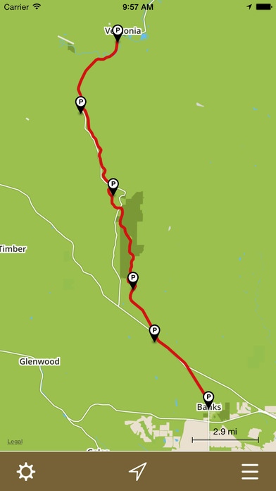
Offline map and trail guide for the Banks Vernonia State Trail in Oregon. Fully interactive map complete with entire trail by segment between official parking areas, GPS location, and elevation profiles. The Banks Vernonia State Trail is a paved rail trail and state park in Northwest Oregon. It runs for 21 miles (34 km), primarily north south, between the towns of Vernonia in Columbia County and Banks in Washington County on an abandoned railroad bed. Banks is about 25 miles (40 km) west of Portland. Cell phone coverage along the Banks Vernonia State Trail is spotty. Our app solves this problem! Once the map is downloaded, you re free to explore the entire trail without a network connection and always know exactly where you are. FEATURES: Simple, easy-to-use interface. Fully interactive offline map. GPS location shown on map. Navigate the trail in its entirety. Turn trail segments on/off between official parking areas Interactive elevation profiles. Trail segment lengths. Parking locations shown on map. Open parking locations in Apple Maps for driving directions General park information. Note: The Banks Vernonia State Trail app is designed for the iPhone. Although it can be installed on GPS-enabled iPads (iPads with Wi-Fi + Cellular), it s not formatted for the larger iPad screen - it runs doubled like all other iPhone apps. Proudly made in Banks Oregon by Scott D. Smith. I sincerely hope you like it!
Requires iOS 8.0 or later. Compatible with iPhone, iPad 2 Wi-Fi + 3G, iPad Wi-Fi + Cellular (3rd generation), iPad Wi-Fi + Cellular (4th generation), iPad mini Wi-Fi + Cellular, iPad Air Wi-Fi + Cellular, iPad mini 2 Wi-Fi + Cellular, iPad Air 2 Wi-Fi + Cellular, iPad mini 3 Wi-Fi + Cellular, iPad mini 4 Wi-Fi + Cellular, 12.9-inch iPad Pro Wi-Fi + Cellular, and 9.7-inch iPad Pro Wi-Fi + Cellular.
About Banks Vernonia State Trail Offline Map, Oregon
Banks Vernonia State Trail Offline Map, Oregon is a paid app for iOS published in the Recreation list of apps, part of Home & Hobby.
The company that develops Banks Vernonia State Trail Offline Map, Oregon is Seasonal Spring LLC. The latest version released by its developer is 1.0.
To install Banks Vernonia State Trail Offline Map, Oregon on your iOS device, just click the green Continue To App button above to start the installation process. The app is listed on our website since 2015-05-30 and was downloaded 2 times. We have already checked if the download link is safe, however for your own protection we recommend that you scan the downloaded app with your antivirus. Your antivirus may detect the Banks Vernonia State Trail Offline Map, Oregon as malware if the download link is broken.
How to install Banks Vernonia State Trail Offline Map, Oregon on your iOS device:
- Click on the Continue To App button on our website. This will redirect you to the App Store.
- Once the Banks Vernonia State Trail Offline Map, Oregon is shown in the iTunes listing of your iOS device, you can start its download and installation. Tap on the GET button to the right of the app to start downloading it.
- If you are not logged-in the iOS appstore app, you'll be prompted for your your Apple ID and/or password.
- After Banks Vernonia State Trail Offline Map, Oregon is downloaded, you'll see an INSTALL button to the right. Tap on it to start the actual installation of the iOS app.
- Once installation is finished you can tap on the OPEN button to start it. Its icon will also be added to your device home screen.
